Parameters and Interpretations
The parameters module allows you to enter your tables of interpreted parameters and the water levels to be taken into account for your project.
To access this module, click on the dedicated button in the taskbar : 
Parameters tab
Create a table
When you access this module for the first time, you will see a number of blocks equal to the number of sectors in your project, each with a button  .
.
As its name suggests, this button lets you create a table in the relevant sector:
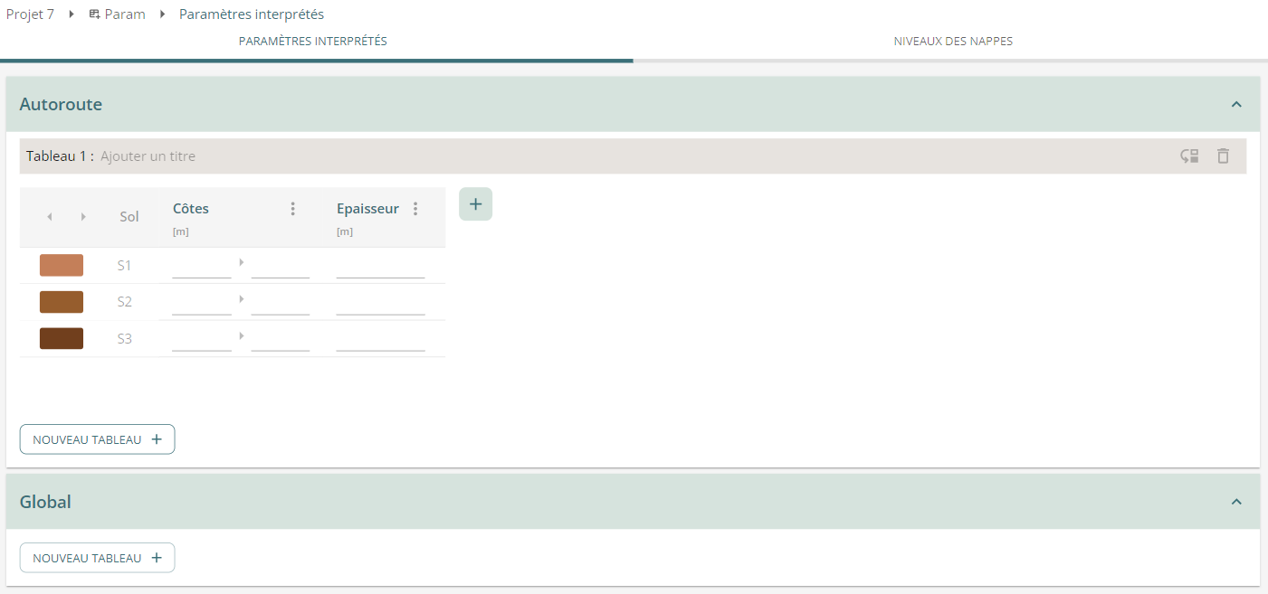
By default, the table contains :
- A number of lines equal to the number of soils in your project;
- A reminder of the colour and Geotech code of each soil;
- The top and base dimensions of the layer. Only the base of the last layer can be edited, the others are deduced from the roofs of the underlying layers.
- The calculated thickness of the soil.
You can add a title to the table in the header row.
There are two icons on the title line:

These are used to move a table from one sector to another, and to delete a table. One of these actions is necessary if you want to delete a sector.
Adding and manipulating columns
You can add columns to your table with the ➕ button.
This opens a selector with a wide choice of parameters, arranged by category. You can type a few letters to quickly search for a parameter:
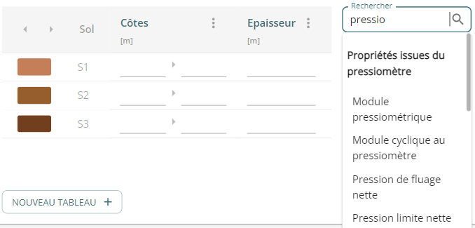
Click on its name and then on ✔️ to add the column.
You can move a column using  .
You must first select it by clicking on its title:
.
You must first select it by clicking on its title:
The  menu also lets you move the column.
You can also delete or hide added columns.
menu also lets you move the column.
You can also delete or hide added columns.
If a column is hidden, a  bubble below the table will redisplay the column.
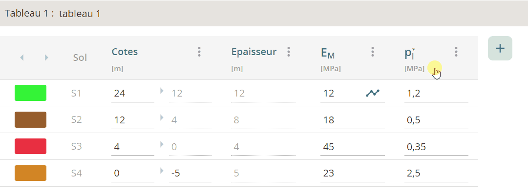
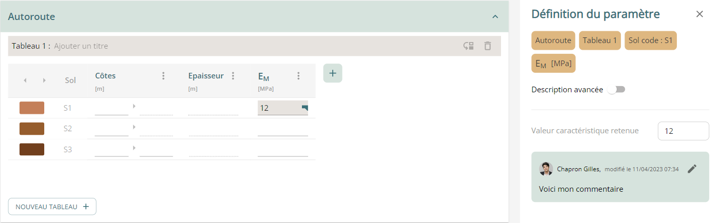
Enter values
To enter a value, simply click on the input box and type in your value:
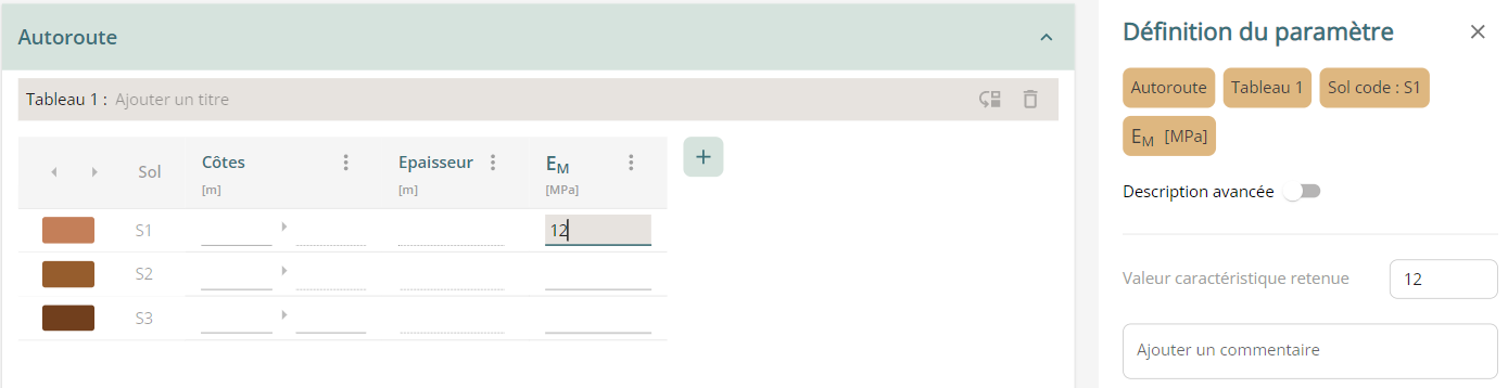
A panel opens on the right, displaying this value and allowing you to :
- enter a comment. The commented values will then be assigned a specific icon in the table:
- enter a more complete description of your parameter by activating the "Advanced description" selector. A special icon then appears in the table, and you can enter not just a single value, but also an average value, a standard deviation, and the minimum and maximum values for your parameter.
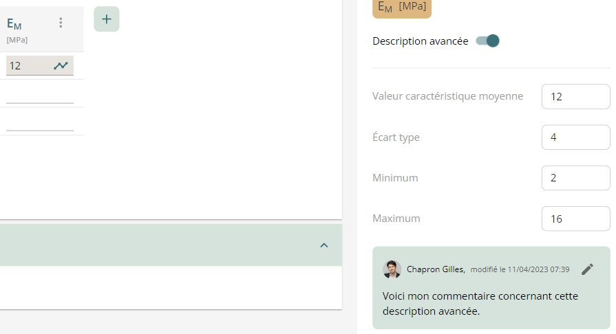
The purpose of this advanced description is to automatically feed the calculation modules to enable sensitivity or range calculations.
Coming soon
D'autres descriptions seront ajoutées au fur et à mesure.
List of columns
The following table lists the columns available in the application:
| French Name (English) | Description | Unit |
|---|---|---|
| Weight Characteristics | ||
| \(\gamma\) | Apparent Volumetric Weight | \(kN/m^3\) |
| \(\gamma_d\) | Volumetric Weight of Dry Soil | \(kN/m^3\) |
| \(\gamma_s\) | Volumetric Weight of Solid Skeleton | \(kN/m^3\) |
| \(\gamma_{sat}\) | Volumetric Weight of Saturated Soil | \(kN/m^3\) |
| \(\gamma '\) | Volumetric Weight of Submerged Soil | \(kN/m^3\) |
| \(\rho\) | Apparent Density | \(kg/m^3\) |
| \(\rho_d\) | Density of Dry Soil | \(kg/m^3\) |
| \(\rho_s\) | Density of Solid Skeleton | \(kg/m^3\) |
| \(\rho_{sat}\) | Density of Saturated Soil | \(kg/m^3\) |
| \(\rho '\) | Density of Submerged Soil | \(kg/m^3\) |
| \(w_n\) | Natural Water Content | % |
| \(S_r\) | Saturation | % |
| \(n\) | Porosity | % |
| \(e_0\) | Void Ratio | - |
| Nature | ||
| \(w_P\) | Plastic Limit | % |
| \(w_L\) | Liquid Limit | % |
| \(w_R\) | Shrinkage Limit | % |
| \(IP\) (\(PI\)) | Plasticity Index | % |
| \(I_C\) | Consistency Index | - |
| \(VBS\) | Methylene Blue Value | % |
| \(GTR\) | GTR Class | - |
| Granulometry | ||
| \(d_{60}\) | 60% Passing | mm |
| \(d_{30}\) | 30% Passing | mm |
| \(d_{10}\) | 10% Passing | mm |
| Properties from Pressuremeter Test | ||
| \(E_M\) | Pressuremeter Module | MPa |
| \(E_r\) | Cyclic Module at Pressuremeter | MPa |
| \(p_f^*\) | Net Creep Pressure | MPa |
| \(p_l^*\) | Net Limit Pressure | MPa |
| \(\alpha\) | Rheological Coefficient | - |
| Properties from Static Cone Penetrometer | ||
| \(q_c\) | Cone Tip Resistance | MPa |
| \(f_s\) | Unit Side Friction on Piezocone | MPa |
| \(R_f\) | Friction Ratio on Piezocone | |
| \(u_2\) | Interstitial Pressure on Piezocone | MPa |
| Properties from Standard Penetration Test | ||
| \(N_{60}\) | SPT Blow Count | |
| Deformability Parameters | ||
| \(E'_0\) | Elastic Modulus (Drained) | MPa |
| \(v\) | Poisson's Ratio | |
| \(E_{50}\) | Average Secant Modulus at First Drained Loading | MPa |
| \(E_{oed}\) | Oedometer Modulus | MPa |
| \(E_{ur}\) | Average Unloading/Reloading Modulus (Drained) | MPa |
| \(E_u\) | Apparent Elastic Modulus (Undrained) | MPa |
| \(v_u\) | Undrained Poisson's Ratio | |
| \(G\) | Shear Modulus | MPa |
| Oedometer Properties | ||
| \(C_c\) | Coefficient of Compression in Oedometer | |
| \(C_s\) | Coefficient of Unloading/Reloading in Oedometer | |
| \(c_v\) | Coefficient of Vertical Consolidation | m²/s |
| \(C_{\alpha}\) | Secondary Consolidation Rate (Creep) | |
| Swelling | ||
| \(\sigma_{g}\) | Swelling Pressure at Constant Volume | kPa |
| Shear Strength Parameters | ||
| \(c^{'}\) | Effective (or Drained) Cohesion | kPa |
| \(\phi^{'}\) | Effective (or Drained) Friction Angle | ° |
| \(\psi^{'}\) | Effective Dilatancy Angle | ° |
| \(c_u\) | Apparent (or Undrained) Cohesion | kPa |
| \(\phi_u\) | Apparent (or Undrained) Friction Angle | ° |
| \(c_R\) | Residual Cohesion | kPa |
| \(\phi_R\) | Residual Friction Angle | ° |
| \(R_C\) | Unconfined Compressive Strength | MPa |
| Stress State | ||
| \(\sigma_{v0}^{'}\) | Average Effective Vertical Stress in Situ | kPa |
| \(\sigma_{p}^{'}\) | Preconsolidation Pressure | kPa |
| \(R_{OC}\) (\(OCR\)) | Overconsolidation Ratio | |
| \(K_0\) | Coefficient of Earth Pressure at Rest | |
| \(K_a\) | Coefficient of Earth Pressure | |
| \(K_p\) | Coefficient of Earth Pressure at Rest on Retaining Structure | |
| Hydraulic Properties | ||
| \(k_h\) | Horizontal Permeability | m/s |
| \(k_v\) | Vertical Permeability | m/s |
| \(k_h/k_v\) | Permeability Ratio |
Groundwater Tab
The 'Groundwater Levels' tab functions in the same way as the one for parameters regarding the creation of tables and their behavior (moving, deleting).
The table created depends on whether one or more water table are declared in the project.
Coming soon
For the moment, only the "single water table" tables are operational.
The tables that allow you to enter the levels of overlaid water tables will soon be operational.
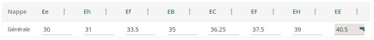
A single water table in the project
If you have declared only one water table in your project, the table created will only include one line allowing you to define the different regulatory tablecloth levels.
You can add a comment to a value, or hide certain columns if they are not useful for your project.
Several overlaid water tables
Coming soon
If several water tables have been declared in the project, the table that will soon be added will make it possible to declare for each formation the water table that bathes it and reconstitute the hydraulic pressure diagram.